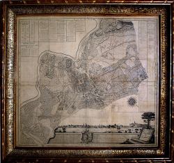
City Plan of Krakow, the so-called Kołłątaj Plan
Surveying and description: Maciej Dębski
Design: Kazimierz Szarkiewicz
The plan was created thanks to the endeavours made by Hugon Kołłątaj (1750-1812) and is connected with the settling of the property matters of the Crown Principal School (Jagiellonian University) during the reforms of the National Education Commission (Komisja Edukacji Narodowej). The plan includes the city of Krakow, and towns of Kazimierz and Kleparz as well as the suburbs and villages of Zwierzyniec, Czarna Wieś, Łobzów, Krowodrza and Grzegórzki. It is bordered in the east by the area of Olsza and the village of Dąbie, in the south by the Vistula River and the Salwator Hill, and in the west by the area of Czarna Wieś and Łobzów through to the area of Krowodrza and Prądnik. At the bottom part of the plan is a panoramic view of Krakow from the west.
1785, Krakow
Pen-and-ink drawing, feint colour wash; woven paper pasted on canvass
Historical Museum of the City of Krakow, ref. no 2104/VIII


